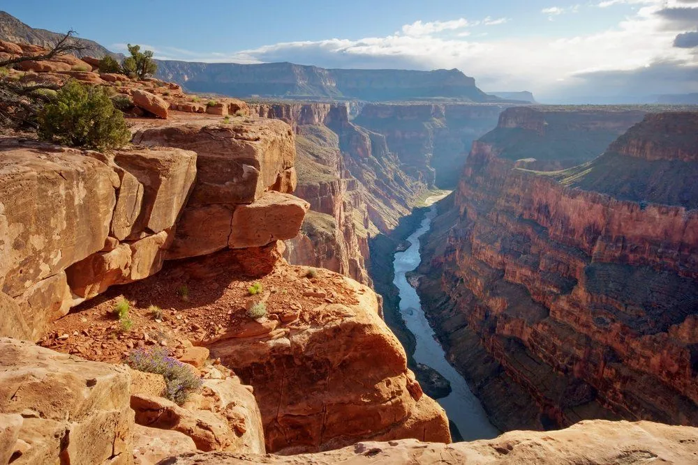
The Grand Canyon was carved by the Colorado River. The river itself integrated into a single canyon-cutting system roughly 5–6 million years ago, but it did so by linking together older paleocanyon segments, some of which began forming up to 70 million years ago as the Colorado Plateau (including the Kaibab uplift) was rising. Once the river had a path through, headward erosion, weathering, and the recent uplift of the plateau combined to deepen the canyon to its present 1.6 km depth.
The Grand Canyon was not formed by a single event in history, but over the course of millions of years. Scientists and geologists believe that there was no canyon in that area around 35 million years ago. The Colorado River flowed across a vast plain. Around the same time, the Kaibab Plateau started to appear right in the middle of the river’s flow. Since the water couldn’t pass over or through the plateau, the river’s course was diverted.
The Grand Canyon in Arizona, US, which contains part of the Colorado River, is a world-famous destination that showcases an unbelievable geological timeline of the world stretching back millions of years. It is a fantastic manifestation of the artful work that nature performs on the surface of Earth – and even beneath it! Thousands of tourists visit this massive canyon every month, making it one of the most popular tourist destinations in the United States.
Let’s take a closer look at how The Grand Canyon was formed.
A Million-Year Journey
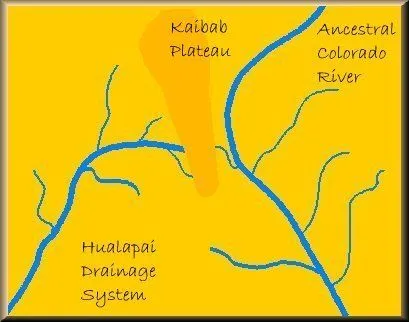
The Grand Canyon was not formed by a single event in history, but over the course of millions of years, which shaped the rocks into the majestic forms and curves we see today. Although scientists have not been able to establish a concrete theory regarding the timeline of formation for the Grand Canyon, almost 35 million years ago, there was no canyon in that area. The Colorado River flowed across a vast plain (its course today is quite similar to the one that existed millions of years ago, but it happens quite a bit lower). Around the same time, the Kaibab Plateau started to appear right in the middle of the river’s flow. Since the water couldn’t pass over or through the plateau, the river’s course was diverted.
The Colorado River Course Change
The river actually split into two parts. The part of the river to the right side of the plateau (see the image below) was diverted in a southeastern direction and began flowing into the Gulf of Mexico, rather than into the Pacific Ocean, where it flowed before the Kaibab Plateau began rising. The left side of the river continued to be a drainage system for the plateau itself and the regions surrounding it on the western side.
Then, approximately 12 million years ago, the flow of the eastern section of the river became blocked and then started forming a huge lake as water continued to accumulate due to a lack of an outlet. This lake is known as Lake Bidahochi.
Erosion Steps In
Even the toughest of rocks cannot stand constant weathering of their surface, resulting in erosion by various agents. In this case, the Kaibab Plateau’s western flank (near the bottom where the river was in constant contact with it) was weakened by a process known as headward erosion (the upstream lengthening of a river channel as the steep head of the cut eats backward into the land). As this process continued, the base of the plateau became weaker and weaker as time passed. Ultimately, it gave way and water broke through the barrier that had been created by the Kaibab plateau and rejoined the original course of the ancestral Colorado River.
As a result, the river assumed a new course (which was quite similar to its original one) due to favorable terrestrial conditions, and Lake Bidahochi lost much of its water. The drainage of the lake through the course of the river resulted in the formation of a gorge through which the Colorado River still flows today.
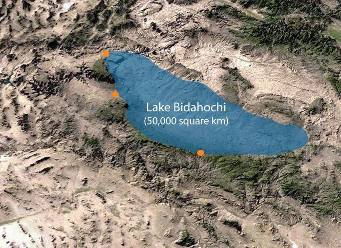
When both these sections of the Colorado River joined forces, their course became wider and deeper and lo and behold! The Grand Canyon was formed! The space that was vacated after Lake Bidahochi drained out was occupied by the Little Colorado River drainage system.
This is just the basic outline of millions of years of erosion and environmental alterations that resulted in the formation of the Great Canyon. There were a host of other factors that also played a part in this entire process, including vulcanism, continental drift, and slight variations in the Earth’s orbit (which in turn causes variations in seasons and climate).
Therefore, next time you find yourself gazing at this majestic piece of natural beauty, consider that you are witnessing not just a gigantic structure, but millions of years of Mother Nature at her most artistic!
How Long Did It Take, And When Did The Grand Canyon Form?

Here is the part that trips most people up: the canyon and the rocks it cuts through are two very different ages. The rocks are ancient. The oldest, the dark Vishnu basement rocks down at river level, formed close to 2 billion years ago, and even the pale Kaibab Limestone capping the rim is about 270 million years old. The walls of the Grand Canyon expose roughly 2 billion years of Earth history, which is one of the most complete rock records on the planet.
The canyon itself, though, is a newcomer. According to the U.S. National Park Service, the Colorado River began carving it just 5 to 6 million years ago, after plate tectonics slowly lifted the whole region into the high, flat Colorado Plateau between about 70 and 30 million years ago. So when someone asks what year the Grand Canyon was formed, the honest answer is that it was not a single year, or even a single million-year stretch, but an ongoing job that the river is still doing today.
Why so quick once it got going? Lifting the plateau steepened the river, and a steeper river cuts down hard and fast. Geologists now think the modern canyon is really several older paleocanyon segments of different ages that the Colorado River stitched together into one continuous gorge 5 to 6 million years ago, like separate roads later joined into a single highway.
Was It Weathering Or Erosion That Formed The Grand Canyon?

This is the question that fills geography homework, and the short answer is: both, but they did different jobs. It helps to keep the two words straight. Weathering is the breakdown of rock in place, by rain, wind, freezing and thawing, and chemical attack. Erosion is the carting away of that loosened material by a moving agent, here, water.
The canyon's astonishing depth is mostly erosion. The Colorado River, fast and loaded with mud, sand and gravel, acted like a slow-moving belt of sandpaper and sawed straight down into the rising plateau. Before the Glen Canyon Dam was finished in the 1960s, the river hauled an average of around 500,000 tons of sediment past any point every single day, which gives you a sense of its cutting power.
The canyon's great width, on the other hand, is largely the work of weathering. Rain, wind, temperature swings and frost gnaw at the exposed walls, and because the region is so dry, the canyon widens only slowly, leaving steep sides rather than a gentle valley. The layers do not wear evenly either: tough limestone and sandstone stand out as sheer cliffs, while softer shale crumbles back into slopes. That alternating cliff-and-slope staircase you see in every Grand Canyon photo is differential weathering made visible. The same tug-of-war between a downcutting river and the rocks it meets is why not every river carves a grand canyon.
Was The Grand Canyon Ever Underwater?

It sounds like a trick question, but the answer is a clear yes, with a twist. The canyon was never carved underwater, that happened on dry, uplifted land. But the rocks that the river later cut through were, in many cases, laid down at the bottom of ancient shallow seas long before any canyon existed.
The proof is sitting right on the rim. The Kaibab Limestone caprock was deposited about 270 million years ago under a warm, shallow sea, and limestone of that kind forms on a sea floor. Lower down, the thick Redwall Limestone was laid down in another shallow sea around 340 million years ago. The National Park Service notes that these marine layers are packed with the remains of sea life, including brachiopods, crinoids, corals, bryozoans, mollusks, and even the teeth of sharks and other fish.
So a hiker standing at the South Rim is quite literally standing on an old sea bed, complete with seashells, that has since been lifted thousands of feet into the air and sliced open by a river. If you have ever wondered what tale buried remains can tell, the canyon walls are a master class in what fossils reveal about a vanished world.
References (click to expand)
- Grand Canyon - Wikipedia. Wikipedia
- How Was the Grand Canyon Formed? - National Geographic Society - nationalgeographic.org:80
- Grand Canyon: Location, Formation & Facts | Live Science. Live Science
- Geology - Grand Canyon National Park. U.S. National Park Service
- Frequently Asked Questions - Grand Canyon National Park. U.S. National Park Service
- Numeric Ages of Grand Canyon Rocks. U.S. National Park Service
- Case Study: Grand Canyon Evolution through the Ages. U.S. National Park Service
- How Was the Grand Canyon Formed? Encyclopaedia Britannica
- New Research Suggests Grand Canyon Is Younger Rather Than Older (Karlstrom et al., Nature Geoscience, 2014). University of New Mexico