Surveyors measured mountain heights with simple trigonometry. From two ground stations at a known distance apart, they used a theodolite (a precision protractor) to measure the angles up to the summit. Knowing two angles and the baseline length, the height of the peak falls out of the sine rule. The ancient Greeks did this for towers and pyramids; Victorian surveyors did it for the Himalayas before GPS satellites took over the job.
One often-told story has it that when the Welsh-born Surveyor General of India, Sir George Everest, measured Mount Everest, then known as Peak XV, to be exactly 29,000 feet tall, his team added two feet to make the number look less round. The reality is a bit different: the height was actually calculated in 1852 by Radhanath Sikdar, the Chief Computer of the Great Trigonometrical Survey, working under Everest’s successor Andrew Scott Waugh. Sikdar landed on 29,000 ft and Waugh added the two extra feet before formally announcing 29,002 ft in March 1856. Everest himself had retired from the Survey in 1843 and never measured the mountain that now bears his name.
Modern technologies like GPS satellites have refined that figure several times since: a 1999 American GPS expedition put Everest at 29,035 ft, and the joint China–Nepal survey announced in December 2020 fixed the currently accepted height at 8,848.86 m (29,031.7 ft). The Survey of India’s 1852 result is still extraordinary given the constraints: Sikdar and his team had no GPS, and they worked from observation stations more than 150 miles south of the peak, because Nepal at the time refused entry to British surveyors. So how did they pull it off?
Trigonometry
As a child, the oldest method I can remember to determine length was to scale it with my hand. A single unit of measurement would be the distance between my thumb and the pinky when the hand was moderately stretched. To measure, say, a table, I would place my stretched hand upon it. Next, the pinky would leap forward, allowing the thumb to take its place, and the length would then measure two units. The scampering would continue until the entire length was accounted for.
Eventually, hands were replaced by rulers, but the methodology remained the same – stack one beside another until the entire length is covered. No one will deny that measuring how tall Mount Everest is with a ruler or your hand is possible, but I’m sure that everyone would agree that the process would be a bit time-consuming and cumbersome.
Yet, the method that geographers rely on isn’t far from using rulers. In fact, Sir Everest and his team implemented high-school geometry to measure the elevation of Mount Everest. Yes, that’s right, their tools were just fancier, more sophisticated sets of rulers and protractors. Trigonometry had been used by the Greeks to measure tall structures and by Victorian surveyors to measure the tallest mountains before we moved onto satellites. However, even satellites measure elevation by essentially implementing the same principle – drawing triangles.
Triangles
Geographers measure elevation by drawing numerous triangles. Amongst the three sides, one is the altitude of the mountain whose elevation must be measured. The base of a triangle is drawn between the mountain’s feet and a point, let’s say A, that is situated at a known distance from the mountain’s feet. The third side can be formed by simply connecting point A and the summit.
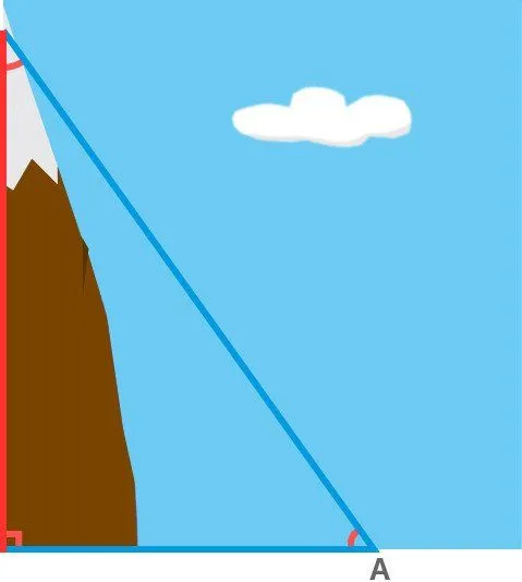
While forming the horizontal base, geographers must ensure that it is completely level to achieve accurate results. The discernment of any irregularity on Earth’s craggy surface is achieved with the help of highly delicate instruments. Next, they must measure all three angles formed within the triangle. This is achieved by using an advanced protractor, known as a theodolite. Measuring even two angles is sufficient, as the third angle can be calculated by subtracting the sum of the two known angles from 180, as the sum of all three angles bounded by a triangle is equal to 180º.
Now, behold the magic of simple trig: the knowledge of two angles and the length of one side can reveal the altitude of the mountain. Even the Greeks measured elevation by “comparing the ratios of two sides of a triangle”, which, if you’ve learned basic trig, is essentially performing the same operation.
For instance, consider a very simple example where the angle formed at point A is 60º, and we only know the distance between point A and the mountain’s base, which is, of course, the triangle’s base. For simplicity, let’s assume the triangle is a right-angled, where the base is perpendicular to the altitude. This implies that the third angle, formed at the summit is 30º (180º-[90º+60º]). Let’s also label the triangle’s sides. Starting from the altitude and going clockwise, let’s label them as X, Y and Z units.
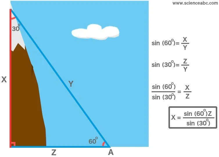
Now, Sin (60º) represents the ratio X/Y, while Sin (30º) represents the ratio Z/Y. If we divide these ratios, we observe that the two Ys cancel out and we are only left with the ratio X/Z. The values of both Sin (60º) and Sin (30º) can be learned by simply referring to a high school math textbook. Furthermore, Z is the base of the triangle, the magnitude of whose length we already know. Multiply Z with the ratios of Sines and we have the altitude (X) of the mountain.
Sikdar and the Survey of India drew several such triangles, all emanating from different observation stations on the Indian plains, as the measurement from any one triangle could not be trusted. The team averaged the altitudes derived from all the triangles, which gave a final figure of exactly 29,000 feet, a suspiciously round number that Andrew Waugh nudged up to 29,002 ft in the official announcement so it would look like a measurement and not a guess.
In 1999, an American GPS expedition led by Bradford Washburn put Everest at 29,035 ft (8,850 m). Two decades later, in December 2020, China and Nepal jointly fixed the currently accepted height at 8,848.86 m (29,031.7 ft). Either way, the 1852 figure is remarkable: Sikdar’s answer was within about 30 feet of the modern reading. Only two angles and one side, and that was it.
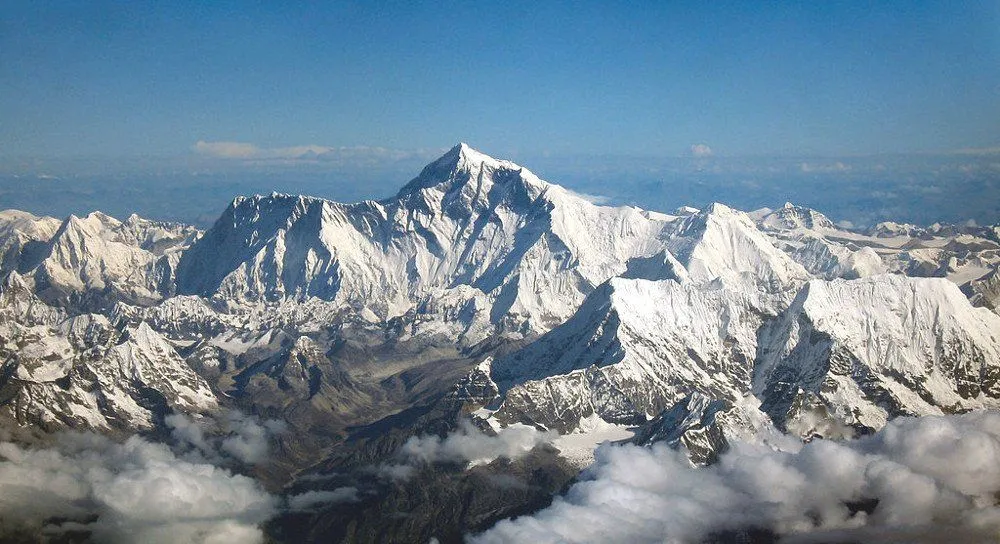
Why Is A Mountain's Height Measured From Sea Level?
When we say Everest stands 8,848.86 m (29,031.7 ft) tall, that figure is not measured from the ground at its base. The peak sits on the roof of the Himalayas, where the surrounding land is already several kilometers up. If every mountain were measured from the valley floor at its foot, its "height" would depend entirely on which valley you happened to pick. To make heights comparable anywhere on Earth, geographers agreed on one shared zero: mean sea level.

Mean sea level is the ocean's average surface, taken over years to iron out tides and waves. Extended in imagination beneath the continents, it traces out a surface called the geoid, which the U.S. National Ocean Service calls "a model of global mean sea level that is used to measure precise surface elevations." The number printed on a map or a summit marker is really a height above this geoid, what surveyors call an orthometric height. The subtle part is that the geoid is not a smooth ball. Earth's gravity is lumpy, because mass is spread unevenly between mountain ranges, dense rock and deep ocean trenches, and water bulges where gravity pulls harder and sags where it is weaker. So the geoid gently rises and dips by tens of meters around the globe, and a careful survey has to account for those wobbles before it can settle on a single trustworthy elevation.
How Did Explorers Measure Altitude With A Barometer?
Trigonometry was not the only trick in the old toolkit. There was a second, completely different method, and it leaned on the weather. In 1648, acting on an idea from Blaise Pascal, his brother-in-law Florin Périer carried a mercury barometer (a Torricelli tube) up the Puy de Dôme, an extinct volcano in central France. At the summit the mercury stood noticeably lower than it had at the foot of the slope. As the UCAR Center for Science Education explains, "at higher elevations... the mercury level in the glass column was lower than it was at lower elevations," simply because there is less air pressing down from above as you climb.

That single observation handed science a portable altimeter. Because air pressure drops in a fairly predictable way with height, reading a barometer tells you roughly how high you are (the same reason water boils at a lower temperature on a mountaintop). For the next two centuries, naturalists and mountaineers, Alexander von Humboldt among them, lugged barometers up slopes to estimate the elevation of passes and peaks. The catch is that air pressure also drifts with the weather and the temperature, so a barometer on its own is far less precise than triangulation. When the Survey of India wanted an exact figure for a giant like Everest, it stuck with the theodolite and trigonometry. But for a quick height in the field the barometer was the explorer's constant companion, and the very same principle still drives the altimeter in an aircraft or a hiking watch today.
How Do We Measure Mountains Today?
The theodolite never fully retired, but satellites now do the heavy lifting. A modern surveyor plants a GNSS receiver (the umbrella term for GPS and its rivals) on the summit and lets it listen to a fleet of navigation satellites overhead. By timing the signals arriving from several satellites at once, the receiver fixes its own position in three dimensions to within a few centimeters.

There is one wrinkle. A raw satellite fix gives height above a smooth mathematical model of Earth called the ellipsoid, not above the lumpy geoid we actually treat as sea level. Converting one to the other means applying a detailed gravity model of the region, which is why a precise mountain survey still involves painstaking gravity readings on the ground. The 2020 re-measurement of Everest shows the full modern kit at work. A Nepali team reached the summit before dawn carrying a GNSS receiver and a ground-penetrating radar, using the radar to separate the solid rock height from the snow cap sitting on top, the first survey to cleanly tell the two apart. China ran its own survey from the Tibetan side using the BeiDou satellite system. The two countries reconciled their results and, in December 2020, jointly announced 8,848.86 m (29,031.7 ft). It is a long way from Radhanath Sikdar squinting through a theodolite from more than 150 miles away, yet the core idea has barely changed: nail down a few precise measurements, then let geometry finish the job.
References (click to expand)
- Shrinking Mount Everest: How to Measure a Mountain. Live Science
- History of Determinations of the Heights of Mountains, Isis .... The University of Chicago
- GUIDING QUESTION - images.nationalgeographic.com
- What is the geoid? National Ocean Service, NOAA
- The History of Atmospheric Discovery. UCAR Center for Science Education
- It's official: Mount Everest is 8,848.86 metres tall. The Kathmandu Post