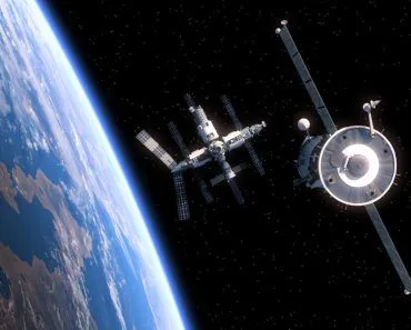
A satellite navigation system uses a constellation of orbiting satellites to fix the geospatial position of any object on Earth. The satellites continuously broadcast their position and the exact time, and a receiver listens to several of them at once to work out precisely where it is. GPS, GLONASS, Galileo, and BeiDou are the four global examples.
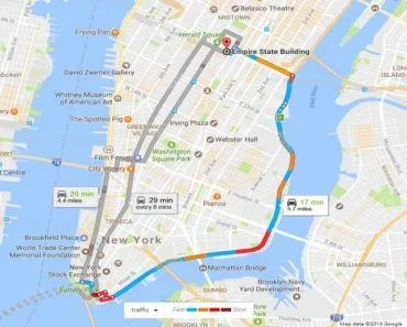
To get directions to a new place, we often use the Google Maps app on our phone and follow it with complete confidence as it guides us to our desired location.
However, have you ever wondered how exactly this feature works to provide those directions to our destination?
The answer to this question has to do a lot with the concept of satellite navigation.
Satellite navigation is a system that uses artificial satellites to determine the geospatial position, i.e., the geographical position of any object. The system is based on information being broadcast in an encoded form that we refer to as the ‘navigation message’, i.e., the signal sent by the satellite (the space segment) to the user device (the user segment) after the satellite has been loaded with navigation data by the ground stations (the control segment).
However, what is it that controls and helps in making a satellite navigation system so efficient and precise?
Global Navigation Satellite System (GNSS)
GNSS refers to a constellation of satellites that relays signals from space to transmit positioning and timing data to the GNSS receivers.

The GNSS is a satellite navigation system that provides global coverage of geospatial positioning. The satellite navigation systems of different countries operate under GNSS. GPS has now become so popular that people mistake every satellite system with GPS, but that is far from the case, as the list below shows!
List Of Satellite Navigation Systems Of Various Countries
Global Positioning System, popularly known as GPS, is the satellite navigation system of the USA. Its first satellite launched in 1978, and the full 24-satellite constellation was declared operational in 1995. GPS provides users with positioning, navigation and timing services, and consists of three segments, namely the space segment, the control segment, and the user segment.
Indian Regional Navigation Satellite System (IRNSS), branded NavIC, is an independent regional navigation satellite system developed by India. Rather than aiming for global coverage, it provides positioning services over India and a region extending roughly 1,500 km (930 mi) around it. Its first satellite (IRNSS-1A) launched on July 1, 2013, the seven-satellite constellation was completed in 2016, and the system became operational in 2018.
Quasi-Zenith Satellite System (QZSS) is a Japanese regional system mainly composed of satellites in quasi-zenith orbits (QZO) that pass nearly overhead Japan. Often referred to as ‘Japanese GPS’, the four-satellite QZSS was declared operational on November 1, 2018, and Japan has since been expanding it toward a seven-satellite constellation.
Galileo is the satellite navigation system of the European Union, with its first two satellites launched on October 20, 2011. It now operates a near-complete constellation of around 30 satellites and provides improved timing and positioning information for users worldwide.
BeiDou is the Chinese satellite navigation system, whose first satellite (BeiDou-1A) launched on October 31, 2000. The third-generation BeiDou-3 reached full global coverage in July 2020.
GLONASS (Global Navigation Satellite System) is the Russian satellite navigation system. Its first satellites launched on October 12, 1982, and the full constellation reached global operation in 1995.

Now that you understand that there isn’t just one Satellite Navigation System on Earth, let’s discuss how critical information is exchanged between the receiver and the sending satellite system. We’re all familiar with the term ‘message’, which is helpful, because satellites use the same term for communication purposes too!
Navigation Message
The navigation message is the message sent by the satellite to the user after retrieving the data from the control segment. Three sets of data are available to determine position and velocity vectors of satellites and these are conveyed in the form of the navigation message, namely almanac data, broadcast ephemerides and precise ephemerides (an “ephemeride” is the position of a celestial body at a given period). The messages sent by the satellite are in the Receiver Independent Exchange Format (RINEX), which is a data interchange format for raw satellite navigation systems.
Wondering how these messages are decoded? To decode any structured message, we first need to know the format it was written in. RINEX is one such format in which navigation messages are exchanged.
Receiver Independent Exchange Format (RINEX)
The Receiver Independent Exchange Format (RINEX) was first proposed in 1989 by Werner Gurtner at the Astronomical Institute of the University of Bern, Switzerland, to simplify the exchange of GPS data collected during the large EUREF 89 surveying campaign. Since then, the format has undergone many changes and is still being modified, with the International GNSS Service (IGS) now maintaining it.
RINEX has gone through several major versions, from version 1 through version 4. For years the version 3 family (such as RINEX 3.03 and the later 3.05) was the working standard, but RINEX 4.00 arrived in December 2021 and RINEX 4.01 in July 2023, adding support for newer signals from constellations such as Galileo and NavIC.
Now, one might think that with so many different satellite navigation systems, it would be difficult to differentiate between them and classify them accordingly.
Let’s explain this by taking an example of navigation messages (both are in RINEX-3.03 format) from two different satellite navigation systems:
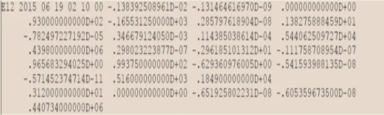
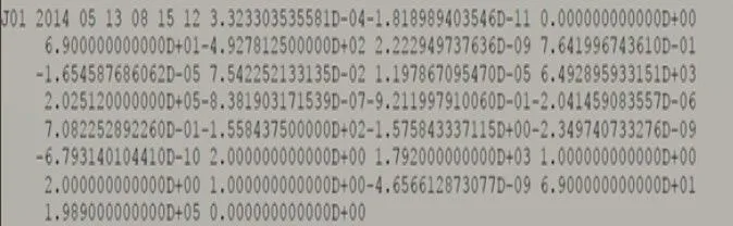
So, can you tell which satellite navigation system the above navigation messages belong to? If not, don’t worry, we’ll decode it together.
The first one is from Galileo, whereas the second is from the Quasi-Zenith Satellite System. If we take a closer look at the start of the message and ignore the rest, we see that the message begins with ‘E’, which represents European Union, whereas the second message starts with ‘J’, which represents Japan.
We know that different satellite systems send navigation messages encoded in their own way, so to read them, we first need to be able to differentiate and identify the given message, then apply the right algorithms to decode it (the usual concepts of data structures come into play here).
Now, coming back to our question on Google Maps, which relies on GPS as its navigation system. Contrary to what many people assume, your phone never transmits anything to the satellites. The satellites simply broadcast their navigation messages continuously, and your phone passively listens to several of them at once. From the tiny differences in when each signal arrives, the receiver calculates its distance to each satellite and pinpoints your location, a process known as trilateration. Google Maps then plots that position on the map and guides you to your destination.
Conclusion
Satellite navigation is a critical satellite-based technology with both commercial and strategic applications. It is of great importance to national security, since these systems can help in locating hostile parties and closely mapping the geography of a given region. Satellite navigation has brought about a revolution in navigation and positioning, and seeing how important such systems are, more and more nations are developing their own constellations to avoid relying on a foreign one.
References (click to expand)
- Overview of the Quasi-Zenith Satellite System (QZSS).
- What is GNSS | EU Agency for the Space Programme.
- IRNSS Programme.
- GPS: The Global Positioning System. GPS.gov.
- 北斗英文首页.
- Search form - www.gsa.europa.eu
- RINEX 4.00 End of Transition Phase and RINEX 4.01 Now Available. International GNSS Service.
- Lesson 1: The GPS Signal. GEOG 862, Penn State College of Earth and Mineral Sciences.