Table of Contents (click to expand)
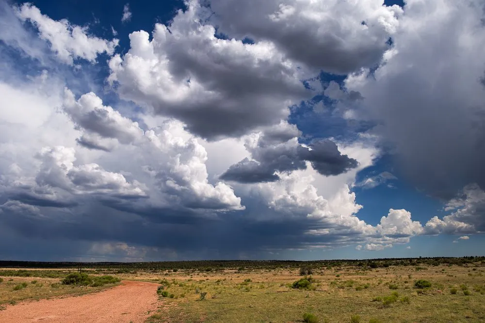
A cumulonimbus cloud is a tall, dense, towering storm cloud built by rising moist air. It forms when an unstable air mass, ample moisture, and an upward push (usually from surface heating) drive air upward, where it condenses into water droplets near the bottom and ice crystals near the top. Bases sit around 2,000–6,500 feet and tops can punch past 40,000 feet, bringing heavy rain, hail, lightning, and sometimes tornadoes.
There are few things as pleasurable or nostalgic as a good summer storm. Sitting under a porch, feeling the humidity fluctuate and the air change, watching the thunderheads roll in… there’s no denying that it feels exciting. However, when you’re looking at that storm blowing in, what you’re probably looking at are cumulonimbus clouds, the largest types of clouds we see in the sky! While most people simply think of them as “storm clouds”, there are a number of fascinating facts about this cloud type that make it worthy of our attention.
What Is A Cumulonimbus Cloud?
A cumulonimbus cloud (often abbreviated Cb) is the towering, dense storm cloud you watch climbing over the horizon on a humid summer afternoon. Meteorologists classify it as the only cloud genus capable of producing the full menu of severe weather, including heavy rain, hail, lightning, and tornadoes. The recipe for one is simple but strict: an unstable air mass, plenty of moisture, and an upward push (typically heat at the surface) that drives warm, moist air upward through the atmosphere.
These clouds are most common in the tropics, where heat and moisture stack up year-round, but they also form frequently across the mid-latitudes during the warm season. In winter, cumulonimbus can even drop brief, intense bursts of snow (called snow squalls) or produce thundersnow, where lightning crackles inside a snowstorm.
As warm, moist air is pulled upward through an unstable atmosphere, a cumulonimbus cloud may start to form. The mature stage is reached when fresh moisture keeps streaming upward and condensing onto tiny airborne particles (condensation nuclei) high in the troposphere. These monumental clouds usually evolve from smaller cumulus clouds, whose bases sit roughly 2,000 to 6,500 feet (600 to 2,000 m) above the ground. From there they keep building until their tops reach the stable layer near the tropopause — about 40,000 feet (12 km) in mid-latitudes, and as high as 60,000 feet (18 km) in the tropics, where the tropopause is higher.
Once a certain tipping point is reached, these massive clouds begin pouring out their stored energy as precipitation, often in brief and violent storms. A typical single-cell cumulonimbus dumps most of its rain in around 20 to 30 minutes and then begins to dissipate, but that short downpour can still trigger flash flooding. Some cumulonimbus clouds, when an organized rotating updraft (a mesocyclone) takes hold during the mature stage, evolve into supercells. Supercells are the rarest of the four thunderstorm types (single-cell, multi-cell, squall-line, and supercell), but they are also the most dangerous, often lasting 2 to 4 hours and producing the strongest hail and the majority of long-track tornadoes. They are most common over the U.S. Great Plains, where the geography reliably mixes warm Gulf moisture with dry continental air aloft.
Cumulonimbus clouds are composed of liquid water droplets near the bottom and ice crystals near the very top, with a mixed-phase region of supercooled droplets and ice in between (part of what makes them so good at brewing lightning and hail). They are often called thunderheads or storm clouds, even if they don't produce precipitation (so-called "dry storms"), because they are typically dark and ominous. The dense column of water droplets and ice crystals absorbs and scatters incoming sunlight, which is what gives the cloud its threatening, slate-grey underside.
Types And Forms Of Cumulonimbus Clouds
To the untrained eye, most storm clouds look the same, but not all cumulonimbus clouds are created equal, and there are some key differences you should understand. According to the World Meteorological Organization's International Cloud Atlas, the two main species of cumulonimbus are Cumulonimbus calvus and Cumulonimbus capillatus, distinguished by what the top of the cloud is doing. In calvus, the upper sproutings have lost their crisp cauliflower texture and look smooth, whitish, and indistinct (a brief transitional stage before glaciation). In capillatus, the top has frozen into ice crystals and looks fibrous or striated, often spreading sideways into the classic anvil shape.
There are also accessory clouds and peripheral features that may accompany cumulonimbus, giving them a distinctive shape, or even hinting at which direction a storm is moving. For example, when you see a large, imposing cumulonimbus with a flat anvil-shaped top, that's an incus. The anvil forms when the rising updraft hits the stable tropopause and can no longer rise — instead, the cloud spreads out horizontally along the underside of that layer. Upper-level winds then drag the anvil downwind, which is why anvils often point away from the storm's direction of travel.
These clouds may line up to form a storm front in what's called a flanking line, or a small funnel will dangle from the cloud base with the potential to spin up into a tornado. Some of these massive clouds also develop pouch-like lobes hanging from the underside of the anvil, called mammatus — those lobes can be 1–3 km wide and form when pockets of cold, moisture-laden air sink out of the anvil. Most cumulonimbus clouds produce precipitation, but, as mentioned, some are known only by their thunder and lightning. In dry-air conditions, the falling rain can evaporate before it reaches the ground (a phenomenon called virga). In desert regions or during drought, these "dry thunderstorms" routinely start wildfires: the cloud-to-ground lightning still reaches the surface and ignites dry fuel, but no rain arrives to put the flames out.
A Final Word
Cumulonimbus clouds are the most iconic, beloved and feared clouds on our planet. They are certainly the most impressive, rolling out from over the horizon like a vengeful wave of anger and retribution. They can bring life-giving rain, but they can also deliver devastating floods and crushing rain, as well as hail or blizzards, depending on the region and local temperature. While these clouds can form anywhere on the planet, they are primarily found in tropical areas, where violent (and brief) summer storms are the norm.
So, the next time you hear a rumble in the distance, bring your friends outside and give them the lowdown on cumulonimbus clouds… just make sure you get back inside before the bottom falls out and the rain begins to pour!
References (click to expand)
- Cloud Classifications and Characteristics.
- What Are the Different Types of Clouds?.
- Pruppacher, H. R., & Klett, J. D. (2010). Microstructure of Atmospheric Clouds and Precipitation. Microphysics of Clouds and Precipitation. Springer Netherlands.
- Cloud Cards.
- Hobbs, P. V., & Rangno, A. L. (1985, December). Ice Particle Concentrations in Clouds. Journal of the Atmospheric Sciences. American Meteorological Society.